Park reopens roads, trails, and backcountry campsites following fire and wind event
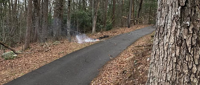
Look Rock Fire started from downed power lines
Great Smoky Mountains National Park officials reopened all roads, trails, and backcountry campsites following closures put in place earlier this week due to the Thomas Divide Fire Complex and the wind event. The Southern Area Gold Incident Management Team has demobilized and several team members are now assisting with fire suppression efforts in Sevier County, along with several National Park Service staff. Approximately 20 firefighters remain on site to continue monitoring the area and to make any needed site repairs from fire suppression activity.
The following areas are now reopened: Backcountry campsites 46, 51, 52, 53, 54, 55, 56, 57, 58, 59, and 60; Deep Creek and Thomas Divide trails from Deep Creek to Newfound Gap Road; Pole Road Creek, Indian Creek, Stone Pile Gap, Deep Creek Horse Bypass, Juney Whank Falls, Deeplow, Fork Ridge, Sunkota Ridge, Martins Gap, Indian Creek Motor Nature, Mingus Creek, Newton Bald, Kanati Fork, and Loop trails. All park roads that are seasonally open this time of year.
Additionally, electrical power to Elkmont, Metcalf, Cataloochee, and Smokemont areas has been restored. Park managers proactively had the power shut off to these areas on Wednesday, March 30 to reduce fire risk across the park. Park rangers responded to one powerline start on Thursday, March 31, from the line servicing the Look Rock telecommunications tower. An engine quickly responded from Blount County and was able to put the fire out before it spread.
For the most up to date information about road closures, follow SmokiesRoadsNPS on Twitter. Please visit https://www.nps.gov/grsm/learn/photosmultimedia/webcams.htm to view images from webcams across the park including Newfound Gap, Clingmans Dome, Look Rock, and Purchase Knob.